SPAP Report No. W-1
These links open new windows to allow you to view the map while reading these sections:
The 1869 List | The Modern Locations in Raymond | Postscript
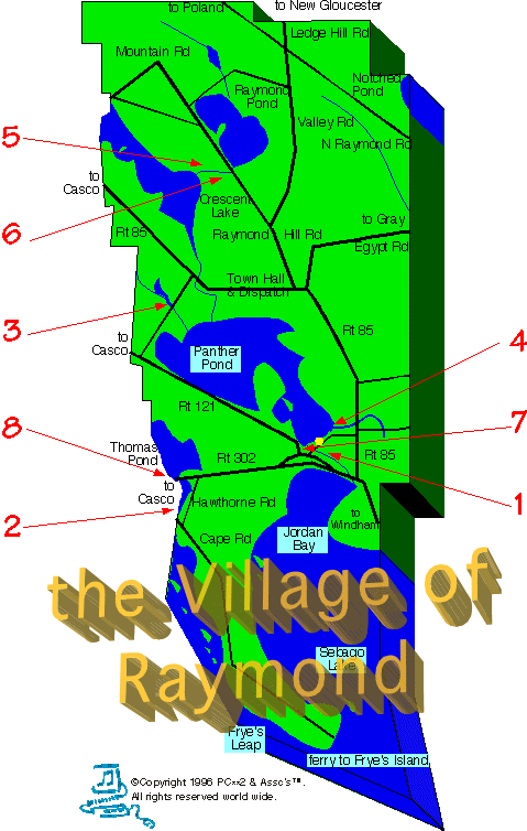
This map has several layers of information in it. The explanations for the numbers on the map are below the image.
1–These mills once were by today’s dam
2–This mill probably was by the modern dam
3–Nubble Brook flows southward under Plains Road
4–This mill was behind today’s Olde House Restaurant
5 & 6–Little Rattlesnake Pond is now Raymond Pond,
7–“A dam at the outlet of Panther pond…”
8–“On the outlet…of Thomas pond…”
*Gems refers to HISTORICAL GEMS OF RAYMOND AND CASCO by Ernest H. Knight (1996), Raymond-Casco Historical Society, Raymond & Casco, ME. This book and others are available, both to read and to buy, at both Raymond Village Library | 207.655.4283, and Casco Public Library, 207.627.4541. Mail-order copies may be obtained from Varney’s Volumes – P.O. Box 84, South Casco, ME 04077 | 207.655.4605.
1st: These mills once were by today’s dam where Panther Run (or River) flows southward under Mill Street, not far from Main Street. Here now is located only the one small building of the State’s salmon-stripping station, which replaces the former multi-building complex (now completely gone) once called Maine State Fish Hatchery #1, which had replaced all of the old mill structures. Here now, every October, the landlocked salmon leap mightily northward at the dam – a sight well worth watching. This multi-purpose milling hub described in the survey lingers on only in the name “Mill Street”. Panther Run/River drains Panther Pond into Jordan Bay of Sebago Lake, and sometimes is also called Jordan River, especially below the dam. (See Gems* Ch VII pp3-7, 30-31, 35-37.)
2nd: This mill probably was by the modern dam where today’s Dingley Brook (which drains Thomas Pond into Sebago Lake) flows under Raymond Cape Road (from South Casco) near its intersection with Hawthorne Road. Dingley Brook is the border between Raymond and Casco today, but both together were called Raymondtown in Nathaniel Hawthorne’s early years thereon. Francis Radoux (for whom Dingley Brook was other-named) was Hawthorne’s step-uncle – see Gems* Ch III pp. 13-17.
3rd: Nubble Brook flows southward under Plains Road to drain beautiful little Nubble Pond into the north shore of Panther Pond, less than a half-mile west of the Tenney River’s entry point. Stonework on the Brook near Nubble Pond implies that the mill-site was north of Plains Road. Just east of the intersection of Plains Road and Coughlan Road (to Kingsley Pines) today, a large “Absolutely No Trespassing” sign now marks the spot where a recent path led a bothersome public into this idyllic spot, alas.
4th: This mill was behind today’s Olde House Restaurant on Route 85, just north of the eastern end of Mill Street, on what is now called Hayden’s Brook (which flows from Brown Road, under Route 85, into Panther Pond’s southeasternmost shore). “Nason’s Stave and Shingle Mill” is what the restauranteurs refer to it as having been called. The barrel staves mostly were for Maine’s major Caribbean Trade, while the shingles were for local building use. (The cooper shop once located at “First”, but not listed above, may have taken some of these barrel staves one step further along.) See old photo of Nason’s Mill, some of which has been moved and built into today’s restaurant, I am told.
5th & 6th: Little Rattlesnake Pond is now Raymond Pond, and Little Rattlesnake River is now Bartlett Brook, draining the Pond into then Great Rattlesnake Pond / now Crescent Lake. This swampy area today is difficult to imagine as once having been doubly-mill-worthy. The mill-damming began right beside Raymond Hill Road, under which the River/Brook flows. (Crescent Lake flows via Tenney River into Panther Pond. Summer camp canoers regularly used to go with the flow into Sebago Lake, making a long but beautiful trip, with minimal carry problems.)
7th: “A dam at the outlet of Panther pond…” Apparently this proposal would mean, today, connecting the west-pointing tip of the southwesternmost shore of Panther Pond to the western shore (the Meadow Road/ Route 121 side). I am told that this now-open-waterway at the point of land separating Panther Pond from Panther Run/River, c.1899: A) was only a trickle through a swampy spot; B) was not navigable even by canoes, which had to be carried around it; C) was part of a very-shallow-water swampy south shore of the pond. Construction of the modern-level dam at Mill Street (see “First” above) supposedly changed conditions A, B,& C just mentioned to the “nicer” modern conditions. Before this 1869 damming proposal, an older canal scheme would have dredged this same spot (see Gems* Ch III p. 9).
8th: “On the outlet…of Thomas pond…” Apparently this proposal would have done exactly the same thing for southern end of Pond that was just described for Panther Pond: dam pond’s immediate exit – at beginning of today’s Dingley Brook, in case.
INTRODUCTION
In 1869, the results of a state-wide survey ordered by Maine’s Governor Joshua Chamberlain (of epic Civil War fame) were published at Augusta. This survey supposedly listed all of Maine’s current and potential water-powered mill sites, town-by-town, alphabetically. The publication was titled THE WATER-POWER OF MAINE, by Walter Wells, Superintendent of the Hydrographic Survey of Maine, Augusta, 1869.
This book is a historian’s delight, with its many local details and simple policy intent. Governor Chamberlain clearly hoped to lead Maine’s millers in a brave countercharge against the invading future, as he had done so successfully with his Maine soldiers against the Rebel charge on Little Roundtop at Gettysburg. Again, Chamberlain was playing his highest card to seize the moment: bayonets in 1863 when the ammunition had run out; water-power in 1869 as Maine’s most basic energy source to tap more effectively.
In the following Report Sections, I have quoted in full what this survey lists for the town of Raymond. Then (with the help of Raymond historian Ernest H. Knight and Casco antiquarian A. Lois Varney) I have attempted to “translate” into today’s river-&-brook names these very different stream labels of 130 years ago. I hope that readers will take at least mental field-trips to seek these reminders of Raymond’s small-scale industries at that time of a great historical “watershed”: the end of the Civil War era and the beginning of America’s Gilded Age.
Unfortunately for Governor Chamberlain, most of Maine’s rural water-powered mini-industries, instead of developing in place, fell victim inevitably to the twin national trends of urbanization and its maxi-industrialization, which were already underway (elsewhere) by 1870. Some existing Raymond mills lasted longer than others, but the potential new mill sites pointed out in this survey were forgotten as easily as the several schemes for potential canal-routes had been lost in an earlier era. Because of all this, Walter Wells’ lists now seem like a roll-call just before a surrender, certainly not a charge – the catalog of a present with a past but no future.
Nonetheless, water-powered mills once were the very makers of our Maine communities, and virtually all of our communities were built on streams because of this simple fact: no water-power, no mills; no mills, no community. If it takes a community to raise a child, surely it took a mill to raise a community. Maine’s water-power survey reminds us of our own local heritage in homely details indeed. Time and water flow, and we all live downstream of the consequences.

Nason’s Stave & Shingle Mill
on Hayden’s Brook
#4 in the above map legend
Photo courtesy of Ernest H Knight and from his Then & Now books about RaymondTown.
See the Raymond Library Section for purchasing these books.
The barrel staves made here were produced mainly for local cooper shops which formed the staves into barrels or hogsheads as they were called. They were then sent to Cuba and returned to America filled with molasses. The shingles were manufactured for local building needs.–from The Olde House restaurant menu.
